
US Postage Stamps
// Philatelic Project
// The Federal States

|
Arizona //
Phoenix, AZ //
Southwest Region //
Mountain Time
(The Grand Canyon State) |

|
|||
| Mexican cession: | February 2, 1848 | |||
| Gadsden Purchase: | December 30, 1853 | |||
| Territory established by CSA: | August 1, 1861 | |||
| Territory organized: | February 14, 1862 | |||
| Statehood granted: | February 14, 1912 // 48th state | |||
| [View map of US territorial acquisitions] | ||||
|
||||

|

|

|
|
#4277 // June 14, 2008
(self-adhesive coil definitive) Flags of Our Nation Series
Arizona State Flag
and Saguaro cacti |
#1955 // April 14, 1982
(ex pane of 50 different stamps) State Bird & Flower of Arizona
Cactus Wren
(Campylorhynchus brunneicapillus) and Saguaro Cactus Blossom |
#1680 // February 23, 1976
(ex pane of 50 different stamps) American Bicentennial Series Arizona State Flag |

|

|
|
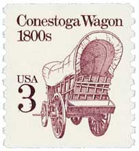
#1028 // November 20, 1953 // Tucson, AZ
Centenary of James Gadsden's (American diplomat, * 1788, † 1858) purchase of territory from Mexico to adjust the US-Mexico boundary (Southern part of Arizona) map showing location of territory, ox-drawn covered Conestoga wagon, group of pioneers and Saguaro cacti |
#1192 // February 14, 1962 // Phoenix, AZ
50th Anniversary of Arizona Statehood Giant Saguaro Cactus (Carnegiea gigantea), view of the Sonora Desert at night |

|
#1443 // October 29, 1971 // San Diego, CA
(ex block of four different stamps) Historic Preservation Issue Mission San Xavier del Bac "White Dove of the Desert" |
| Historic Spanish Catholic mission, founded in 1692 by Jesuit Padre Eusebio Francisco Kino, the present building was constructed from 1783-1797. The pilgrimage site is located about 10 mi [16 km] south of downtown Tucson, AZ, on the Tohono O'odham (Papago) San Xavier Indian Reservation. | |

|

|
|
#774 // September 30, 1935 // Boulder City, NV
Dedication of Boulder Dam National Historic Landmark |
#4269 // June 6, 2008 // McLean, VA
Express Mail® Stamp with "USPS" microprint, pressure-sensitive adhesive (PSA) gum Painting of the Hoover Dam (originally named "Boulder Dam") |
|
The Hoover Dam, a National Historic landmark and major tourist attraction, is located in the Black Canyon of the
Colorada River on the state border between Arizona and Nevada. The both commemorative stamps (above) show a viewpoint looking upstream the Colorada River with Clark County, NV, on the left side of the stamps and
Mohave County, AZ, on the right. The water reservoir created by the Hoover Dam is Lake Mead.
The concrete arch-gravity dam was constructed in Art Déco architectural style between 1931/1936 during the Great Depression and was dedicated on September 30, 1935, by Franklin D. Roosevelt (* 1882, † 1945), 32nd US President (in Office 1933 - 1945). Before a joint resolution of US Congress in 1947 officially named the dam in honor of Herbert Hoover (* 1874, † 1964), 31th US President (in Office 1929 - 1933), the dam was commonly known as Boulder Dam, named after nearby Boulder City, NV, which was originally built in 1931 as federal company town by the Bureau of Reclamation and Six Companies, Inc. as housing area for workers contracted to build the dam on the Colorado River. Heavily travelled US Route 93 ran along the dam's crest until October 19, 2010, when the Hoover Dam Bypass (Mike O'Callaghan-Pat Tillman Memorial Bridge) was opened to traffic. |
|
|
#4627 // February 14, 2012 // Phoenix, AZ
100th Anniversary of Arizona Statehood Cathedral Rock, sandstone rock formation of Sedona, AZ |

|

|
#3563 // April 4, 2002
(ex pane of 50 stamps, one for each state) Greetings from Arizona Illustration of contemporary postcard in the style of the 1930s/1940s View Arizona state quarter View Arizona state map View Arizona clock |

|
|
The origin of the name Arizona is uncertain. Perhaps the source is a word from
the language of the Tohono O'odham Indian tribe meaning "little spring". |
||

|
Land Area
rounded mi2 [km2] 113,635 [294.313] ranked 6th |
Population
(census 2010) 6,392,017 ranked 16th |
Population Density
per mi2 [km2] of land area 56 [22] ranked 35th |
| The State of Arizona has 15 counties. | |||

|
Arizona shares in the south a 389-mile-long (626 km)
international border with the Mexican state of Sonora. |
||

|
Historic Route 66 leads 401 miles (645 km) through Arizona.
Please click on license plate  to view a really bad cartoon.
|
||

|
#UX127 // January 13, 1989 // Tucson, AZ
Stamped Postal Card America the Beautiful Series Red-tailed Hawk and Sonora Desert with Giant Saguaro Cacti at Sunset |
|
#UX176 // August 11, 1994 // Chinle, AZ
Stamped Postal Card Canyon de Chelly National Monument Canyon de Chelly National Monument was established on April 1, 1931. It is located in northeastern Arizona and owned by the Navajo Indian Nation. The name "chell(e)y" derives from the Navajo Indian word "tséyi?", which means "inside the rock". |

|
| // Elmar R. Göller // All rights reserved // Contact // Publishing Information |
| modified |

