
US Postage Stamps
// Philatelic Project
// The Federal States

|

|
||||||||||

|

|

|
|
#4279 // June 14, 2008
(self-adhesive coil definitive) Flags of Our Nation Series
California State Flag
and coastal area |
#1957 // April 14, 1982
(ex pane of 50 different stamps) State Bird & Flower of California
California Quail
(Lophortyx californica californica) and California Poppy |
#1663 // February 23, 1976
(ex pane of 50 different stamps) American Bicentennial Series California State Flag |

|

|
|
#773 // May 29, 1935 // San Diego
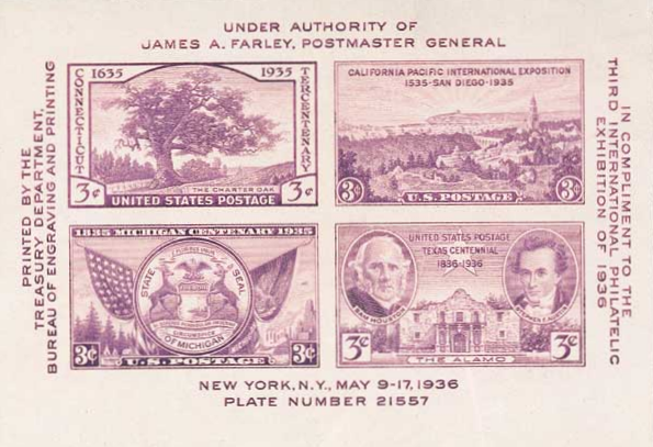
#778b // May 9, 1936 // NYC Souvenir Sheet California Pacific International Exposition in San Diego, CA, celebrating the 400th anniversary of Coronado's discovery of the southwest Pacific Francisco Vázquez de Coronado y Luján, Spanish conquistador, (* ca. 1510, † 1554) View of San Diego Bay, CA, and exposition area |
#2704 // September 28, 1992 // San Diego, CA
450th Anniversary of the exploring journey of Juan Rodriguez Cabrillo (* ca. 1499; † 1543) On June 27, 1542, the Portuguese explorer set sail from New Spain (present-day Mexico) in search of a water route between the Atlantic and the Pacific Ocean. Three months later, he landed at present-day San Diego, CA. Since no portrait exist of this famous conquistador, the stamp depicts an artist's conception. |

|

|

|
|
#954 // January 28, 1948
California Gold Centennial Sutter's Mill, Coloma, CA |
#997 // September 9, 1950
100th Anniversary of California Statehood S.S. Oregon, Gold Miner, and Pioneers |
#3316 // June 18, 1999
150th Anniversary of California Gold Rush Gold Miners |

|

|
|
#1373 // July 16, 1969 // San Diego, CA
California Settlement Bicentennial Carmel Mission Belfry |
#1725 // September 9, 1977 // San Jose, CA
Founding of "El Pueblo de San José de Guadalupe", First Civil Settlement in Alta California Bicentennial Farm Houses |

|

|
|
#1442 // October 29, 1971 // San Diego, CA
(ex block of four different stamps) Historic Preservation Issue San Francisco Cable Car The cable car system was invented by Andrew Smith Hallidie (* 1836, † 1900). The first run took place on August 2, 1873, at 4 a.m., on Clay Street in San Francisco. Present-day the cable car still operates on ten miles [16 km] of track. |
#3438 // September 8, 2000 // Sacramento, CA
150th Anniversary of California Statehood Big Sur and Iceplant |
|
The Spanish Heritage of California
Missions period: 1769 - 1833 |
|

|

|
|
#C116 // August 22, 1985 // San Diego, CA
Air Mail Stamp Junipero Serra, O. F. M. (* 1713, † 1784) Spanish Franciscan friar and missionary, founder of the California mission system Portrait (design from a Spanish stamp), Outline map of Southern California, San Gabriel Arcángel Mission founded on September 8, 1771 [Official name: "La Misión del Santo Príncipe El Arcángel, San Gabriel de Los Temblores"] |
#4650 // February 28, 2012 // Carmel, CA
Express Mail® Stamp Carmel Mission "San Carlos Borroméo del Río Carmelo" was founded on June 3, 1770 by Father Junipero Serra and was the second in what would become a chain of twentyone Spanish missions along the coast of California, each positioned about one day's ride on horseback from the next. Father Junipero Serra is buried at the mission church. |

|
#3565 // April 4, 2002
(ex pane of 50 stamps, one for each state) Greetings from California Illustration of contemporary postcard in the style of the 1930s/1940s View California state quarter View California state map View California clock |

|
|
The name California references to a mythical land described in a popular
novel of the 15th century "Las Sergas de Esplandián", written by Spanish author Garci Ordóñez de Montalvo (* ca. 1440, † ca. 1504). |
||

|
Land Area
rounded mi2 [km2] 155,959 [403.932] ranked 3rd |
Population
(census 2010) 37,253,956 ranked 1st (highest of all states) |
Population Density
per mi2 [km2] of land area 239 [92] ranked 12th |
| The State of California has 58 counties. | |||

|
South California shares a 140-mile-long (225 km) international
border with the Mexican state of Baja California Norte. |
||

|
Historic Route 66 leads 514 miles (505 km) through California
and terminates in Santa Monica, Los Angeles County, CA at the intersection of Olympic Blvd/Lincoln Blvd. For reasons of tourism and business, however, the western point of America's Mother Road was officially moved on November 11, 2009 to the Santa Monica Pier, a famed landmark in Victorian-era look. A sign was put up to officially name the pier the "End of the Trail". |
|
The Spanish Heritage of California
Ranchos period: 1784 - 1821 |

|
|
#UX104 // September 16, 1984 // Compton, CA
Stamped Postal Card Historic Preservation Series The California Ranchos Bicentennial Juan Jose Dominguez (Spanish soldier * 1736, † 1809) Adobe Rancho, San Pedro, original size 48,000 acres (194 km2) (The first rancho concession from the Spanish crown) |
| // Elmar R. Göller // All rights reserved // Contact // Publishing Information |
| modified |
