
US Postage Stamps
// Philatelic Project
// The Federal States

|
Iowa // Des Moines, IA //
Midwest Region //
Central Time
(The Hawkeye State) |
|
| Territory established: | July 4, 1838 |
| Statehood granted: | December 28, 1846 // 29th state |
| Iowa was formed out of land from the Louisiana Purchase. | |
| [View map of US territorial acquisition] | |

|

|

|
|
#4291 // September 2, 2008
(self-adhesive coil definitive) Flags of Our Nation Series
Iowa State Flag
and field of corn |
#1967 // April 14, 1982
(ex pane of 50 different stamps) State Bird & Flower of Iowa
Eastern Goldfinch
(Carduelis tristis) and Wild Rose |
#1661 // February 23, 1976
(ex pane of 50 different stamps) American Bicentennial Series Iowa State Flag |

|

|
|
#838 // August 24, 1938 // Des Moines, IA
Iowa Territory Centennial Old State Capitol until 1857, Iowa City, Johnson County, IA |
#942 // June 1, 1946 // Iowa City, IA
Iowa Statehood Centennial Iowa State Flag and Outline Map |
|
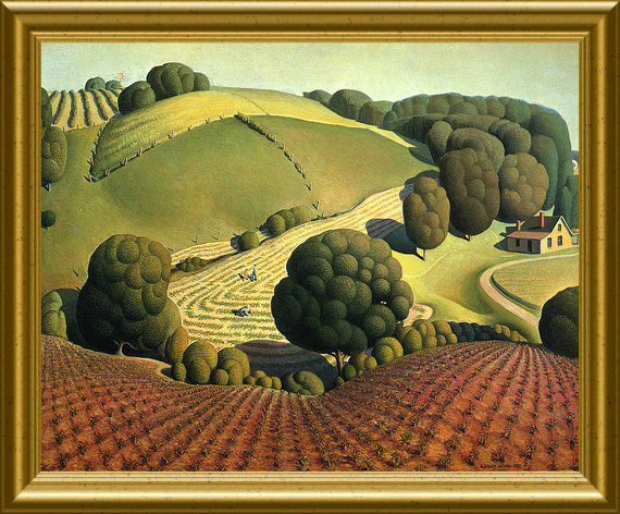
#3088/89 // August 1, 1969 // Dubuque, IA
(water activated/self adhesive gum) Iowa Statehood Sesquicentennial "Young Corn", based on a painting by Grant Wood (American painter, * 1891, † 1942) |

|

|
#3575 // April 4, 2002
(ex pane of 50 stamps, one for each state) Greetings from Iowa Illustration of contemporary postcard in the style of the 1930s/1940s View Iowa state quarter View Iowa state map View Iowa clock |
|
|
The state and the Iowa River are named after
the Iowa(y) Indians, a Sioux tribe. |
||

|
Land Area
rounded mi2 [km2] 55,869 [144.700] ranked 23rd |
Population
(census 2010) 3,046,355 ranked 30th |
Population Density
per mi2 [km2] of land area 55 [21] ranked 36th |
| The State of Iowa has 99 counties. | |||

|
|
#UX123 // July 2, 1988 // Burlington, IA
Stamped Postal Card Iowa Territory, 1838 Sesquicentennial Harvesting Corn Fields |
| // Elmar R. Göller // All rights reserved // Contact // Publishing Information |
| modified |
