
US Postage Stamps
// Philatelic Project
// The Federal States

|
Montana // Helena, MT //
Western Region //
Mountain Time
(The Treasure State, The Big Sky Country) |
|
| Territory established: | May 28, 1864 |
| Statehood granted: | November 8, 1889 // 41st state |
|
Montana was formed out of land from the
Louisiana Purchase (1803)
and the British cession (1846). |
|
| [View map of US territorial acquisition] | |

|

|

|
|
#4304 // April 16, 2010
(self-adhesive coil definitive) Flags of Our Nation Series
Montana State Flag
mountain lion in the snow |
#1978 // Apr 14, 1982
(ex pane of 50 different stamps) State Bird & Flower of Montana
Western Meadowlark
(Sturnella neglecta) and Bitterroot |
#1673 // February 23, 1976
(ex pane of 50 different stamps) American Bicentennial Series Montana State Flag |

|

|
|
#858 // November 8, 1939 // Helena, MT
50th Anniversary of Statehood (North Dakota, South Dakota, Montana, Washington) Maps of the Anniversary States |
#2401 // January 15, 1989 // Helena, MT
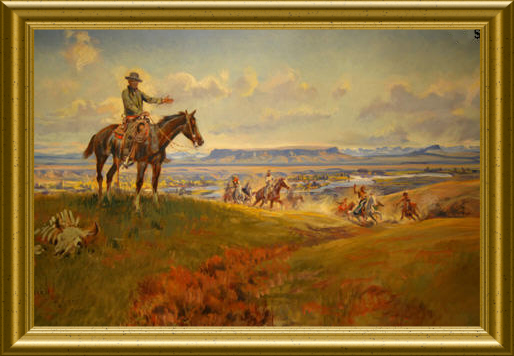
Montana Statehood Centennial "C. M. Russel and Friends", painting by Charles Marion Russel (* 1865, † 1926), US American painter of the Old American West |

|
#3586 // April 4, 2002
(ex pane of 50 stamps, one for each state) Greetings from Montana Illustration of contemporary postcard in the style of the 1930s/1940s View Montana state quarter View Montana state map View Montana clock |
|
|
The state name derives from the Spanish word "montaña",
which means "mountains".
Montana is the home of the Grasshopper Glacier,
named for the grasshoppers that can still be seen frozen in ice. |
||

|
Land Area
rounded mi2 [km2] 145,552 [376,978] ranked 4th |
Population
(census 2010) 989,415 ranked 44th |
Population Density
per mi2 [km2] of land area 7 [3] ranked 49th |
| The State of Montana has 56 counties. | |||

|
Montana shares in the north on the
49th parallel
a 545-mile-long [877 km]
international border with the Canadian provinces of British Columbia (BC), Alberta (AB) and Saskatchewan (SK). |
||
| // Elmar R. Göller // All rights reserved // Contact // Publishing Information |
| modified |
