
US Postage Stamps
// Philatelic Project
// The Federal States

|
Washington // Olympia, WA //
Western Region //
Pacific Time
(The Evergreen State) |
|
| British cession: | June 15, 1846 |
| Territory established: | March 2, 1853 |
| Statehood granted: | November 11, 1889 // 42nd state |
| [View map of US territorial acquisition] | |

|

|

|
|
#4328 // August 16, 2012
(self-adhesive coil definitive) Flags of Our Nation Series
Washington State Flag
and evergreen forests |
#1999 // April 14, 1982
(ex pane of 50 different stamps) State Bird & Flower of Washington
American Goldfinch
(Carduelis tristis)
and Rhododendron
|
#1674 // February 23, 1976
(ex pane of 50 different stamps) American Bicentennial Series Washington State Flag |

|

|

|
|
#858 // November 2, 1939
50th Anniversary of Statehood (North Dakota, South Dakota, Montana, Washington) Maps of the Anniversary States |
#1019 // March 2, 1953
Washington Territory Centennial Medallion (ox-drawn schooner, pioneer, and state flower Rhododendron), early pioneer family viewing Washington landscape |
#2404 // February 22, 1989
Washington Statehood Centennial Mt. Rainier (Stratovolcano, 14,411 ft [4.392 m]), canoe on Mirror Lake |
|
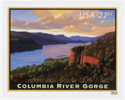
#5041 // January 17, 2016 // Washington, DC
Priority Mail ExpressTM Stamp The stamp is the 16th in a series of American Landmarks started in 2008 Columbia River Gorge
Showing a view facing east the stamp depicts the majestic gorge as sunset approaches with the historic »Vista House«, sitting atop »Crown Point« and overlooking the river 725 feet [221 m] below.
|

|
| Millions of years ago, the Columbia River cut through the Cascade Mountains and formed a deep gorge more than 80 miles [129 km] long and up to 4,000 feet [1.219 m] deep. Native Americans built large communities along its shores and it became a busy center for trade. The river's location made the area important for westward expansion. The »Lewis and Clark« expedition discovered in 1805 the Columbia River was the »Gateway to the Pacific«. Today, the gorge forms part of the border between the states of Washington and Oregon. | |

|
#3607 // April 4, 2002
(ex pane of 50 stamps, one for each state) Greetings from Washington Illustration of contemporary postcard in the style of the 1930s/1940s View Washington state quarter View Washington state map View Washington clock |
|
|
The state is named in honor of George Washington (* 1732, † 1799),
first President of the United States of America (1789 - 1797). |
||

|
Land Area
rounded mi2 [km2] 66,544 [172.348] ranked 20th |
Population
(census 2010) 6,724,540 ranked 13th |
Population Density
per mi2 [km2] of land area 101 [39] ranked 26th |
| The State of Washington has 39 counties. | |||

|
Washington shares in the north on the
49th parallel a 427-mile-long
(687 km) international border with the Canadian province of British Columbia (BC). |
||

|
|
#UX164 // May 9, 1992 // Stevenson, WA
Stamped Postal Card Columbia River Gorge Up to 4,000 feet [1.219 m] deep, the canyon stretches for over 80 miles [129 km] as the Columbia River winds westward through the Cascade Mountain Range forming the boundary between the States of Washington and Oregon. |

|
|
#UXC27 // May 15, 1999 // Denver, CO
Stamped Postal Card Mt. Rainier, WA The majestic stratovolcano, 14,411 feet [4.392 m], is the center of Mount Rainier National Park, established in 1899 |
| // Elmar R. Göller // All rights reserved // Contact // Publishing Information |
| modified |
