
US Postage Stamps
// Philatelic Project
// The Federal States

|
Wisconsin // Madison, Dane County, WI //
Midwest Region //
Central Time
(The Badger State) |
|
| Territory established[1]: | July 4, 1836 |
| Statehood granted: | May 29, 1848 // 30th state |
| [1] Wisconsin was formed out of land from the Northwest Territory. | |
| [View maps of Northwest Territory] | |

|

|

|
|
#4330 // August 16, 2012
(self-adhesive coil definitive) Flags of Our Nation Series
Wisconsin State Flag
and dairy cattle |
#2001 // April 14, 1982
(ex pane of 50 different stamps) State Bird & Flower of Wisconsin
Robin
(Turdus migratorius) and Wood Violet |
#1662 // February 23, 1976
(ex pane of 50 different stamps) American Bicentennial Series Wisconsin State Flag |

|

|
|
#739 // July 7, 1934 // Green Bay, WI
Perforation 11 |
#755 // March 15, 1935
collectors issue imperforated and ungummed |
|
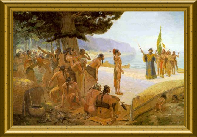
Wisconsin Tercentennary
Jean Nicolet arriving on the shores of Green Bay of Lake Michigan, based on a painting (1904) by Edward W. Deming (* 1860, † 1942) Jean Nicolet (* 1598, † 1642), French explorer, had been seeking a short route to China, but instead became the first white man to reach the territory now comprising the State of Wisconsin. |
|

|
#957 // May 29, 1948 // Madison, WI
Wisconsin Statehood Centennial Map of Wisconsin on scroll, State motto "FORWARD", State Capitol, Madison, WI (built in 1906/1917 in Beaux-Arts architectural style) |

|

|
|
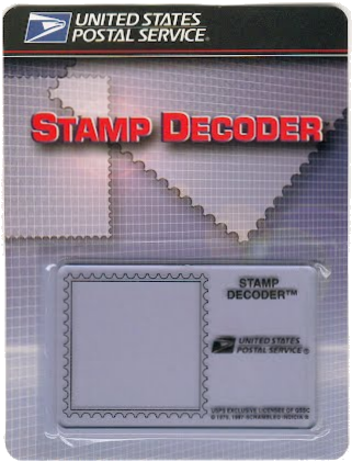
#3206 // March 19, 1998 // New York, NY
(Hidden "badger" image) Wisconsin Statehood Sesquicentennial Farmland and Farm buildings |
The stamp contains the hidden image
of a "badger" (see yellow marking). Please click on stamp to display enlarged size for better viewing. Those covert designs are only visible when viewed through the special lense of the USPS Stamp Decoder device. |

|
#3609 // April 4, 2002
(ex pane of 50 stamps, one for each state) Greetings from Wisconsin Illustration of contemporary postcard in the style of the 1930s/1940s View Wisconsin state quarter View Wisconsin state map View Wisconsin clock |
|
|
The state name is based on the Chippewa Indian word "ouisconsin",
believed to mean "grassy place". |
||

|
Land Area
rounded mi2 [km2] 54,310 [140.662] ranked 25th |
Population
(census 2010) 5,686,986 ranked 20th |
Population Density
per mi2 [km2] of land area 105 [40] ranked 25th |
| The State of Wisconsin has 72 counties. | |||

|
|
#UX113 // July 3, 1986 // Mineral Point, WI
Stamped Postal Card Wisconsin Territory Sesquicentennial Miners, Shake Rag Street Housing |

|
|
#UX301 // February 5, 1999 // Madison, WI
Stamped Postal Card University of Wisconsin-Madison, Bascom Hill, Sesquicentennial Bascom Hill, featured on the stamp, is the main quadrangle that forms the symbolic core of the University of Wisconsin campus. The architectural complex was built in 1849 mainly in Gothic and Romanesque style. Bascom hill and hall are named after John Bascom (* 1827, † 1911), sixth President (1874 - 1887) of the University of Wisconsin-Madison. |
| // Elmar R. Göller // All rights reserved // Contact // Publishing Information |
| modified |
