 US Postage Stamps
// Philatelic Project
// Micronesia
US Postage Stamps
// Philatelic Project
// Micronesia
US Postage Stamps
// Philatelic Project
// Micronesia
US Postage Stamps
// Philatelic Project
// Micronesia

|
Micronesia
UN Trust Territory of the Pacific Islands (TTPI) |

|
|
After the end of the Pacific War[1] the
Micronesian
archipelagos, Mariana Islands (except Guam Island), Caroline Islands, and Marshall Islands, became the UN[2] Trust Territory of the Pacific Islands (TTPI) on July 18, 1947. The UN trusteeship replaced the League of Nations'[3] South Pacific Mandate effective on June 28, 1919, and under administration of the Japanese Empire from December 17, 1920 until US military forces occupied Guam and Saipan (Mariana Islands) in June/July 1944.
The UN Security Council delegated the administration of the TTPI to the United States of America, effective July 18, 1947. Until 1951 the TTPI was administered by the US Navy based in Guam, afterwards by the US Department of the Interior from a base in Saipan until the US administration ended on November 3, 1986. The UN Security Council formally ended the trusteeship for Mariana Islands, Caroline Islands (Islands of Chuuk, Yap, Kosrae, Pohnpei), and Marshall Islands districts on December 22, 1990. Finally the trusteeship for the Palau District (Western Caroline Islands) ended on May 25, 1994. |
||
|
The following political entities evolved out of the TTPI's districts:
Commonwealth of the Northern Mariana Islands, unincorporated US territory, established between 1976/1986 Republic of the Marshall Islands, constitutional government established on May 1, 1979, independence under COFA[4] on October 21, 1986 Federated States of Micronesia, constitutional government established on May 10, 1979, independence under COFA[4] on November 3, 1986 Republic of Palau, constitutional government established on January 1, 1981, independence under COFA[4] on October 1, 1994 |
||

|
[1] The Pacific War, part of World War II, started with a military strike of the Imperial Japanese Navy against the US naval base Pearl Harbor, located on O'ahu Island, US Territory of Hawai'i, on December 7, 1941. The war ended with the unconditional surrender of the Japanese Empire on September 2, 1945 after the US Air Force dropped an atomic bomb on the Japanese cities of Hiroshima (August 6, 1945) and Nagasaki (August, 9, 1945). | |

|
[2] The United Nations Organization was established after World War II on 24 October, 1945 in New York, NY, USA, by fifty-one member states, and was the successor organization of the League of Nations[3]. | |

|
[3] The League of Nations (predecessor institution of the UN[2]) was established after World War I on June 28, 1919 by fourty-four member states, administrative center was based at the Palace of Nations in Geneva, Switzerland. | |
|
|
[4] Free association with the United States of America under the Compact of Free Association (COFA). The USA provide defence, funding grants and access to US social services for citizens of the associated State. | |
|
Republic of the Marshall Islands
[Aolepān Aorōkin M̧ajeļ] Majuro // Micronesia // Marshall Islands Time (MHT) |
|
| UN trusteeship: | July 18, 1947 - December 22, 1990 |
| US administration: | July 18, 1947 - November 3, 1986 |
| Constitutional government established: | May 1, 1979 |
| Independence under COFA[4]: | October 21, 1986 |
| UN admittance: | September 17, 1991 |
| Inauguration of MH Postal Service: | May 2, 1984 |
| View map of the Marshall Islands | |
|
Inauguration of Postal Independence
Marshall Islands - USPS Postal Agreement First Issue of Postage Stamps of the Marshall Islands |

|
|
#1 - 4 // May 2, 1984 // Majuro, MH
Traditional outrigger canoe - Fishnet Stickchart - Islet |
|
|
The Republic of the Marshall Islands is an island state consisting of two archipelagic island chains (Ralik and Ratak group) of 29 atolls, each made up of many small islets, and five single islands in the North Pacific
Ocean, about half way between Hawai'i and Australia. The islands and islets are of coral reef types and rise only a few feet above sea level. Majuro, the capital and largest city of the Republic is located on the same-named atoll of the Ratak chain. The Majuro atoll has 64 islands, the neighborhoods of the capital spread across the Derap, Uliga, and Darrit islands.
The Marshall Islands were named for the British sea captain John Marshall (* 1748, † 1819), who sighted them in 1788. The official languages are English and Marshallese. The official currency is the US dollar (USD, US$). US nuclear test site Between 1947 and 1962 the Eniwetok and Bikini atolls were used by the US forces as a test site for hydrogen and nuclear devices. The test of the first US hydrogen bomb in 1952, code-named "Ivy Mike", destroyed the island of Elugelab in the Enewetak atoll. The largest nuclear test the US forces ever conducted, code-named "Castle Bravo" took place in the Bikini atoll. The people of Bikini were resettled to another island, and a total of 23 US atomic and hydrogen bomb tests were conducted. Despite cleanup attempts, the atoll islets remain uninhabited because of nuclear contamination. The USA paid the Marshall Islands US $183.7 million as damages in 1983, and another one-time $3.8-million payment to the relocated people of the Bikini atoll was approved in 1999. The Kwajalein atoll hosts the US Army Reagan Missile Test Site, a key installation in the US missile defense network. |
||

|
Land Area
rounded mi2 [km2] 70 [181] Coast line 230 mi [370 km] |
Population
(2009 estimate) 68,000 |
Population Density
per mi2 [km2] of land area 971 [376] |
|
Federated States of Micronesia
Palikir // Micronesia // Pohnpei (PONT) and Yap (YAPT/CHUT) Time |
|
| UN trusteeship: | July 18, 1947 - December 22, 1990 |
| US administration: | July 18, 1947 - November 3, 1986 |
| Constitutional government established: | May 10, 1979 |
| Independence under COFA[4]: | November 3, 1986 |
| UN admittance: | September 17, 1991 |
| Inauguration of FM Postal Service: | July 12, 1984 |
| View maps of the Federate States of Micronesia | |
|
Joint issue by the USA and the Federate States of Micronesia.
Fourth anniversary of the ratification of the Compact of Free Association between the USA and the Federate States of Micronesia. |
|

|
US Postage Stamp Issue
#2506 // September 28, 1990 // Washington, DC Traditional Micronesian outrigger canoe and FSM State flag |

|
|
|
FM Postage Stamp Issue
#124 - 126 // September 28, 1990 // Palikir, FM (RMI) Stick chart, traditional Micronesian outrigger canoe, and RMI State flag (USA) USS Constitution, US State flag "Star-Spangled Banner", Micronesian Kingfisher, and American Eagle (FSM) Traditional Micronesian outrigger canoe and FSM State flag |
|
|
Inauguration of Postal Service
Federate States of Micronesia - USPS Postal Agreement First Issue of Postage Stamps of the Federate States of Micronesia |

|
|
#1 - 4 // Jul 12, 1984 // Palikir, FM
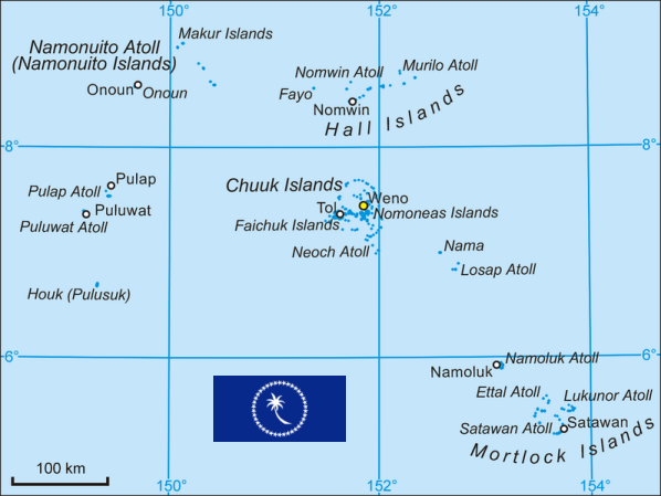
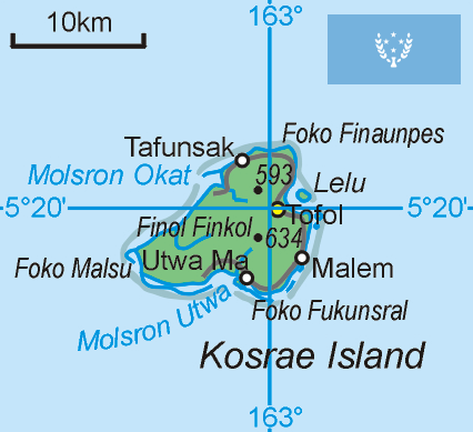
Outline maps of the four states of the federation State of Yap - State of Truk State of Pohnpei - State of Kosrae |
|
|
The Federated States of Micronesia are an island nation formed out of the widely scattered archipelago of the
Caroline Islands (except Palau) in the North Pacific Ocean 2,500 miles southwest of
Hawai'i. The western Caroline Islands group of Yap and the eastern groups of Chuuk (Truk), Pohnpei (Ponape), and Kosrae (Kosaie) adopted a constitution in 1979 and chose to become the Federated States of Micronesia. Each state has considerable autonomy and is equally unique with its own geography, ecology, language and culture. The nation's capital, Palikir, is located on Pohnpei Island in the same-named State.
The official languages are English (government, commerce) and eight major indigenous languages: Yapese, Ulithian, Woleaians, Chuukese, Pohnpeians, Kosraeans, Nukuoro, and Kapingamarangi. The official currency is the US dollar (USD, US$). The FSM cannot economically survive without US financial aid. |
||

|
Land Area
rounded mi2 [km2] 271 [702] Coast line 3,798 mi [6,112 km] |
Population
(2013 estimate) 106,100 |
Population Density
per mi2 [km2] of land area 392 [150] |
|
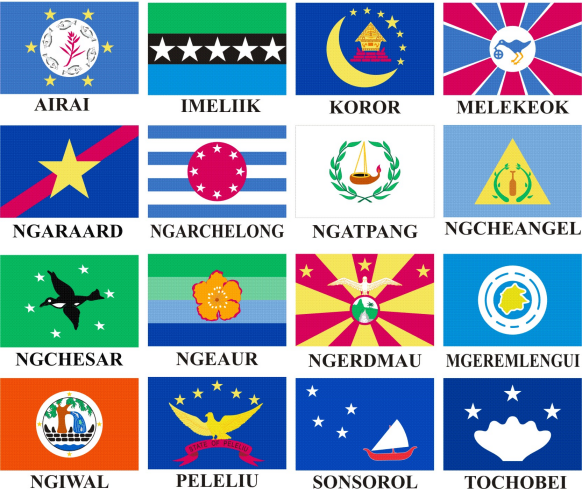
Republic of Palau
[Beluu er a Belau] Ngerulmud // Micronesia // Palau Time (PWT) |
|
| UN trusteeship: | July 18, 1947 - May 25, 1994 |
| US administration: | July 18, 1947 - November 3, 1986 |
| Constitutional government established: | January 1, 1981 |
| Independence under COFA[4]: | October 1, 1994 |
| UN admittance: | December 15, 1994 |
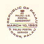
| Inauguration of Palau Postal Service: | March 10, 1983 |
| View map of the Republic of Palau | |
|
Joint issue by the USA and the State of Palau.
First anniversary of independence of the State of Palau. |
|

|
US Postage Stamp Issue
#2999 // September 29, 1995 // Agana, GU Marine life and Palau State flag |

|

|
|
Cock/hen Palau Fruit-Dove
(Ptilinopus pulchellus), and Palau State flag |
Rock Islands Southern Lagoon, Koror State
UNESCO World Heritage Site, and Palau State flag |

|

|
| Map of Palau Islands and State flag | Orchid, Hibiscus, and Palau State flag |
|
PW Postage Stamps Issue
#947 - 950 // October 1, 1995 // Melekeok, PW (Set of four stamps) |
|
|
|
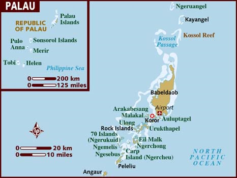
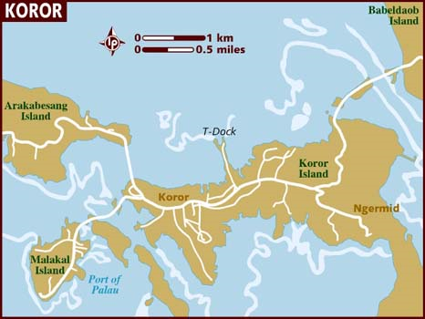
The Republic of Palau is an island state formed out of the westernmost portion of the Caroline Islands in the North Pacific Ocean, including the larger islands of Angaur, Babulthuap, Eil Malk, Koror, Peleiu and
Urukthapel. Most of the ca. 350 islands are small low-lying coral islets, surrounded by barrier reefs. The exception is the largest island, the mountainous Babulthuap Island of volcanic origin. The Palau Constitution designates sixteen traditional municipalities of Palau as states. The nation's capital, Ngerulmud is located in the State of
Melekeok on the east coast of Babulthuap Island.
The official languages are English and Palauan. The official currency is the US dollar (USD, US$). The Rock Island Southern Lagoon, Koror State, has been inscribed on the UNESCO World Heritage List in 2012. |
||

|
Land Area
rounded mi2 [km2] 177 [458] Coast line 944 mi [1,519 km] |
Population
(2012 estimate) 21,030 |
Population Density
per mi2 [km2] of land area 119 [46] |
| // Elmar R. Göller // All rights reserved // Contact // Publishing Information |
| modified |


