
US Postage Stamps
// Philatelic Project
// The Federal States


|
|
||||||||||

|

|

|
|
#4295 // August 6, 2009
(self-adhesive coil definitive) Flags of Our Nation Series
Maine State Flag
and moose |
#1971 // April 14, 1982
(ex pane of 50 different stamps) State Bird & Flower of Maine
Chickadee
(Parus atricapillus), White Pine Cone and Tassel |
#1655 // February 23, 1976
(ex pane of 50 different stamps) American Bicentennial Series Maine State Flag |
|
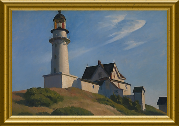
#1391 // July 9, 1970 // Portland, ME
Maine Statehood Sesquicentennial Lighthouse at Two Lights, Cape Elizabeth, ME, westernmost approach of Casco Bay entrance, built in 1874 in Gothic Revival architectural style, geographic coordinates: 43° 33' 56" N - 70° 12' 00" W The stamp design is based on an oil painting (1929) by Edward Hopper (American realist painter, * 1882, † 1967) The painting hangs in the Metropolitan Museum of Art, New York City, NY. |

|

|
#3579 // April 4, 2002
(ex pane of 50 stamps, one for each state) Greetings from Maine Illustration of contemporary postcard in the style of the 1930s/1940s View Maine state quarter View Maine state map View Maine clock |
|
|
Reference to the region as "Maine" first appeared in writing in 1622,
however the origin of the state name is ambiguous.
The region was named after the former traditional French province of Maine,
what is now the French region of Pays de la Loire or it is probably a practical nautical term "The Main Land", which served to distinguish the land mass from the numerous surrounding islands.
Maine is known for its seafood cuisine, especially
lobsters and clams.
|
||

|
Land Area
rounded mi2 [km2] 30,862 [79.932] ranked 39th |
Population
(census 2010) 1,328,361 ranked 41st |
Population Density
per mi2 [km2] of land area 43 [17] ranked 39th |
| The State of Maine has 16 counties. | |||

|
Maine shares in the west, north, and east a
611-mile-long (983 km) international border with the Canadian provinces of Quebec (QC) and New Brunswick (NB). |
||

|
|
#UX173 // October 14, 1993 // Brunswick, ME
Stamped Postal Card Massachusetts Hall, Bowdoin College, Brunswick, Maine National Historic Landmark Massachusetts Hall (built 1799/1802) is the original home of Bowdoin College in Brunswick, ME, and the oldest college building in Maine. The college is named in honor of James Bowdoin III (* 1752, † 1811), philanthropist, agrarian reformer, and statesman, who donated land and money to found the college. |
| // Elmar R. Göller // All rights reserved // Contact // Publishing Information |
| modified |